
This first map is of Islamic concentration in the greater London area. If someone is familiar with the city, could they please grab this map, put the names of the places listed on the second map and send the image back in?

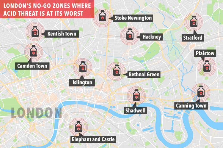
Now The Sun map of acid throwing no-go zones for certain services and classes of people at night. Women and delivery people for example.
Related article about another area cleft in twain by lots of Islamic enrichment.
BRADFORD is “heading towards disaster” and the Council has allowed racial hatred and the perception of fear to “become a real problem”, the chairman of a scrutiny committee has warned.
Councillor Arshad Hussain, who chairs Bradford Council’s corporate overview and scrutiny committee, said there were”many areas in this city” where people were afraid to go, depending on their ethnicity.
Cllr Hussain (Lab, Toller) branded the situation a “horrible state of affairs” as the committee discussed a new report on community cohesion and how the Council’s diversity and cohesion team was working to strengthen community relations. The report said the team was working with all religious groups and other organisations in its response to the Louise Casey report on opportunity and integration, which gives recommendations to the government.
H/T GB., ML. and M.

Hi Eyeore, the second map is not to the same scale. It is basically centered around the region of Tower Hamlets and stretching to nearby districts. This is the ‘East End’ that used to be the lair of the Cockneys. Of course, they are all gone now and only those too poor to remain are left.
On the first map the dots would be clustered very close together. I’ll have a bash at adding them to the first map, and perhaps the borough boundaries …
Thank you! Alternatively, if you are aware of a better and easier map to work with, please link us to it. What we want to know of course, is whether or not the first map, showing areas made too dangerous for some people and services, is connected to a higher concentration of muslims in that area. While I am confident that in some manner, this is correct, it would be interesting to see it in related maps. However, sadly, even if the maps do not overlap, its just as likely that the perpetrators of these acid attacks are Muslims and probably largely from Pakistan where the ‘tradition’ seems to have started. But related maps would be meaningful in any case. So thank you for your effort on this, and again, if you can find a map of Islamic demographics which more closely resembles the one from The Sun, use that one.
Eeyore.
Hi Eeyore,
I’ve prepared two maps. One with the London Boroughs shown, and one without. The boroughs clutter up the map, but you can see Tower Hamlets and Newham are ‘ground zero’ for highest risk. My money is you are not in the least surprised by this 🙂
https://s3-us-west-1.amazonaws.com/ankhdjedseneb/LondonBoroughs.png
https://s3-us-west-1.amazonaws.com/ankhdjedseneb/LondonAcidAttacks.png
What is interesting is that the attacks are not where the concentration of Muslims is high (which is presumably already Sharia-compliant), but where a high concentration of Muslims borders a low concentration area. I guess that ‘Sharia gradient’ is the enforcement of how Sharia spreads to neighboring areas.
You can also see that in regions where the concentration is zero the region is not a high-risk zone, eg. City of London. With the media mostly hiding this and the Powers That Be not venturing much outside the City on foot then the Powers can deny what is going on.
ps. I’m not a cartographer, and I’m about as far from London as it is possible to be, but I have been there a few times. I may be a little off in the zone placement vertical scale and I’ve also slightly moved zone locations a little so everything is readable, If any Londoners are worried by this, don’t worry, in a decade the zones will all have grown 🙁
I’ve created a zoomed version of Central London not too dissimilar to the Sun scale
https://s3-us-west-1.amazonaws.com/ankhdjedseneb/CentralLondonAcidAttacks.png
I should acknowledge the source for the borough information. Here it is:
https://londonmap360.com/london-boroughs-map
Happy New Year to all.
It is London related…
Man tries to jump tube barriers and gets stuck by his genitals –
From the description:
Man tries to jump tube barriers and gets stuck by his genitals
A ‘fare-dodger’ who apparently tried to jump the barriers at a London Underground station really was struck by karma after his manhood became stuck in the doors.
The man’s screams of agony can be heard as people line up to witness the incident.
Police and London underground staff members worked to free the young man from his entrapment at Covent Garden tube station.
Crowds gathered around the gates to watch as the man’s screams became louder and some called for ‘butter’ to free him.
Finally, officers are able to free the man to cheers from the growing crowd as the man is let down safely.
Before he staggers away the man can be seen turning back on himself to hug the members of staff and police officers who helped.
At first his friends seem to be trying to calm him down but as the video continues and the audience expands, a jeering nature seems to occur.
I think this qualifies for a dumb crook of the month award.